

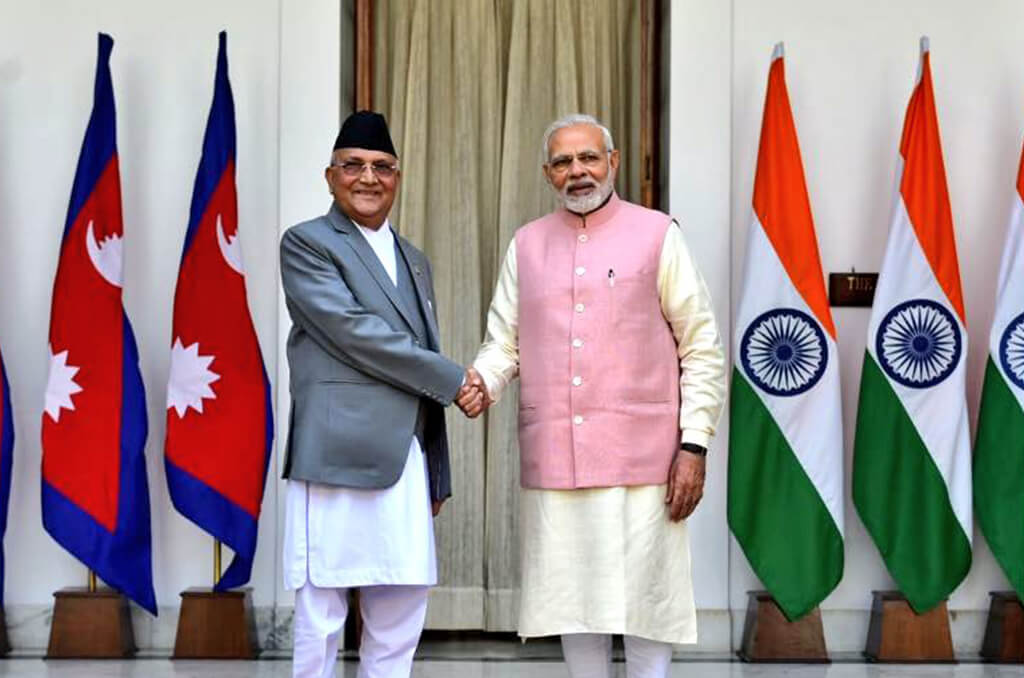
Despite the fact that Nepal and India are neighbours, who share a unique relationship of friendship and cooperation characterized by open borders and deep-rooted people -to -people contacts of kinship and cultures, they do not always have the most amicable relations. Their cordial relations get disturbed from time to time due to different reasons such as an economic embargo/blockade on Nepal for about two months by India, India’s claim that Gautam Buddha was born in India, India’s interference in Nepal’s internal affairs, territorial disputes between two countries, etc. India seems to have been suffering from superiority complex as it regards itself as big brother of Nepal and always tends to show big brotherly attitude towards Nepal which can never be accepted by Nepal which itself enjoys a glorious history of being an independent, sovereign and never colonized state.
Recently, Nepal and India are indulged in a cartographic war because of long-standing dispute over the border area of Kalapani. Amid the havoc of COVID 19 around the world and while the whole humanity is fighting against corona virus, Nepal and India, keeping the serious threats of corona virus a side, are quarrelling with each other for the territorial regions Kalapani, Lipulekh and Limpiyadhura.
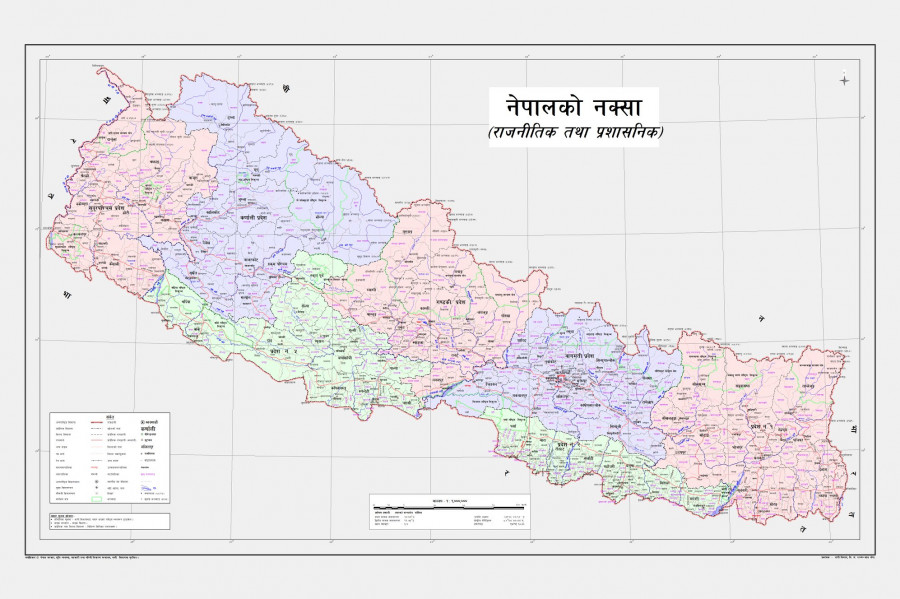
The Kalapani Issue :
Where is Kalapani located?
Kalapani is a region located in Darchula district, Sudurpaschim Pradeh of Nepal. Ii is also the easternmost corner of Uttarakhand’s Pithoragarh district of India. It shares a border on the north with the Tibet Autonomous Region of China. The region resembles a slice of cake wedged in between Limpiyadhura, Lipulekh and Kalapani. The area is in India’s control but Nepal claims the region because of historical and cartographic reasons. The area is the largest territorial dispute between Nepal and India consisting of at least 37,000 hectares of land in the High Himalayas.
Kalapani is the first big reason behind Indo-Nepal border controversy, followed by Lipulekh. Lipulekh is located in a far west point near Kalapani, an area of territorial dispute between India and Nepal. Both the countries claim these regions as part of their territory. India claims Kalapani as part of Pithoragarh district of Uttarakhand and Nepal claims it as a part of its Dharchula district.
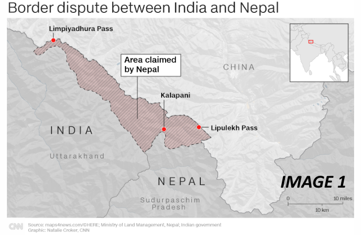
Map 1: Have a look at the map of Kalapani.
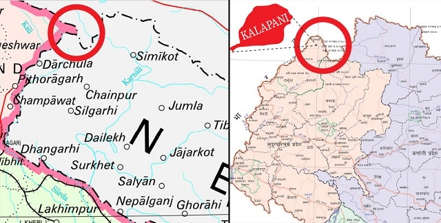
Kalapani Territorial Dispute Between India & Nepal
Kalapani, largely a valley, appears on the Kailash Manasarovar route and is located at an altitude of 3600m, bordering India’s Uttarakhand and Nepal’s Sudur Paschim Pradesh. Kalapani is majorly formed of Himalayan rivers know by the names Kali, Mahakali or Sharda in India & Nepal.
India and Nepal are bound to settle all the boundary disputes including Kalapani through bilateral talks under an agreement signed in 1998.
Some questions concerned with Kalapani Territorial Disputes are :
Who controls the Kalapani area?
India’s Indo-Tibetan Border Police has been controlling the Kalapani and nearby areas since the Indo-China war of 1962.
What is Nepal’s claim over Kalapani?
Nepali Government claims that towards the west of Kalapani flows the main Kali river which falls in its territory. As per the Treaty of Sugauli, the Kali River is located in Nepal’s western border that it shares with India. The treaty was signed between Nepal and British East India Company in 1816.
What is India’s claim over Kalapani territory?
Indian Government claims that a ridgeline located towards the east of Kalapani territory is a part of the Indian Union. The treaty of Sugauli mentions nothing about this ridgeline.
Why has there been dispute between India & Nepal over Kalapani?
Though treaty of Sugauli clearly mentions about the Kali River and its location in Nepal, there were a few subsequent maps drawn by British surveyors which show the origin of Kali river from different places. This digression from the treaty led to territorial disputes between India and Nepal. Even the size of Kalapani is different in various sources. Indeed, the Kalapani area is of strategic significance in South Asian diplomacy as it serves as a tri-junction between India, China and Nepal. Given that Nepal is a “buffer state” between the other two countries—both with great-power aspirations in the region—the Kalapani dispute has important ramifications on the relations between the three.
Three aspects of territorial dispute between India & Nepal
Treaty of Sugauli: Nepal and the British East India Company in 1816 signed the Treaty of Sugauli to end the territorial war. The treaty demarcated Uttarakhand’s Kumaon with River Kali as a boundary between India and Nepal. However, the river Kali has been shifting its course from time to time.
Origin of Rival Kali: The place of its origin is also not known. India claims that the river origins from streams of Kalapani and Nepal claims that river originates from its Kuthi Yankti stream.
Key to the disagreement over Kalapani is the origin of River Kali. There are varied views regarding this river and its source. The government of Nepal holds the view that the river which flows to the west of Kalapani is the main River Kali, originating at either Limpiyadhura or the nearby Lipulekh pass, which are both within the Nepalese territory, thus justifying the area as an inherent part of Nepal. India, for its part, argues that the River Kali originated from a smaller rivulet named Pankhagad, lying on the southern portion of Kalapani and the subsequent ridge on the eastern part of this area is the true border, and therefore making the territory part of India.
Gunji Village: River Kali bisects the Byans area and the southeast of Byans includes the Gunji village which is claimed by Nepal as its territory. Gunji village is the gateway for Mansarovar Yatra. The Byans and its areas were transferred to Nepal by Britishers following the Treaty of Sugauli
Lipulekh Territorial Dispute Between India & Nepal
Lipulekh pass is located atop the Kalapani at a tri-junction between India, China and Nepal. The Indo-Nepal border dispute over Lipulekh dates back to 1997 when for the first time Nepal raise objections against the decision of India and China to open Lipulekh pass for travelling to Mansarovar.
Lipulekh pass is an ancient route made for trade and pilgrimage purposes by Bhutiya people. The route was closed by India following the Indo-China war of 1962. However, lately in the beginning of May 2020, India reopened the route for Kailash Mansarovar pilgrimage after constructing 22 km long road on the pass.
Map 2 : Depicting Lipulekh

Why Lipulekh is a disputed territory between India and Nepal?
Lipulekh pass opens from Gunji village. Nepal claims that the village and the road is its territory. On the other hand, India and China signed a trade treaty in 1954 declaring Lipulekh pass as the Indian gateway. Moreover, both the countries signed another treaty in 2015 for trading through Lipulekh Pass. However, this time Nepal protested against the move staking claim over Kalapani area.
Map 3: The following map shows Kalapani, Lipulekh and Limpiyadhura the disputed territories between Nepal and India


What do the Maps tell with reference to the present territorial disputes between Nepal and India?
It can be clearly understood from the following maps how India has encroached Nepalese territories over periods of time.
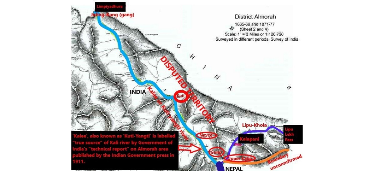
Map 4 : This is the map published by the East India Company, the British and the Indian governments in various years. It shows how the origin of the Kali river has been manipulated to extend India’s territory beyond the Kali and into Nepal.

Map 5 : This map was also published by the East India Company on 1st February, 1827. It shows the source of the Kali River is Limpiyadhura. If the source of the Kali River is Limpiyadhura as shown in the map, then there remains no doubt in the fact that the villages of Gunji, Kuti and Nabi fall inside Nepal and they are Nepalese territories.

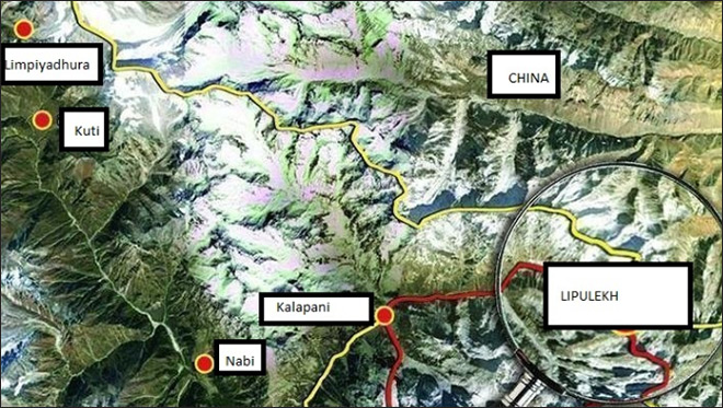
Map 6 : Map depicting the Lipulekh Pass along with Kalapani
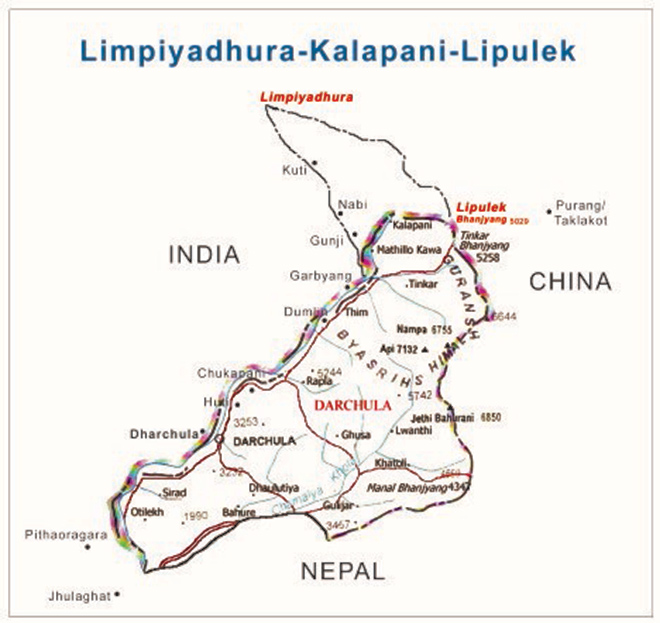
Map 7 : Depicting Limpiyadhura, Kalapani and Lipulekh
Legal provisions for resolving territorial disputes between the two countries :
The Sugauly Treaty(1816):
The Sugauly Treaty is the one and only most authentic and reliable legal document to sort out the present territorial dispute between Nepal and India. This treaty was signed between the East India Company and Nepal on 4th March, 1816. This legal document defines the border between Nepal and India. It clearly designates the Kali River as Nepal’s western border. Both the countries agree on the point that the Kali River is the demarcation line between them but they have dispute regarding the origins of this river. According to Nepal’s experts, the east of the Kali river should begin at the source of the river. The source according to them is in the mountains near Limpiyadhura, which is higher in altitude than the rest of the river’s flow. Nepal claims that a land mass, high in the mountains that falls to the east of the entire stretch starting from Limpiyadhura downwards, is theirs. India on the other hand says the border begins at Kalapani which India says is where the river begins. The dispute is mainly because of the varying interpretation of the origin of the river and its various tributaries that slice through the mountains. While Nepal’s claim of the territory east of Kali is based on the Limpiyadhura origin, India says the river actually takes the name Kali near Kalapani.
The recent developments of the Kalapani territorial dispute :
Two centuries long dispute over Kalapani regions between Nepal and India was revived in November 2019 when India published a revised political map showing the newly created Union Territories of Jammu and Kashmir and Ladakh. Both India and Nepal lay claim to Kalapani. The map showed Kalapani as part of Pithoragarh district. Nepal protested immediately and drew attention to the lingering issue. On May 8, India inaugurated the Darchula-Lipulekh pass link road, cutting across the disputed Kalapani area which is used by Indian pilgrims to Kailash Mansarovar. Nepal hit back by summoning the Indian Ambassador to Nepal, Vinay Mohan Kwatra, to convey a formal protest. The link road passes through territory at the Lipulekh pass that Nepal claims as its own territory. Nepal had also expressed displeasure on the 2015 agreement between India and China for using the Lipulekh pass for trade without consulting Nepal.
The government of Nepal has already sent three notes of protest to the government of India through the Indian Ambassador and has requested them to sit together and solve the territorial dispute through the dialogues but the Indian side has not responded to the notes of the Government of Nepal. Nepal proposed to hold bilateral talks with India to solve the border issue, but the Indian side didn’t show any interest. India unilaterally published its map earlier and built and inaugurated the road at the tri-junction point without consulting Nepal. This clearly shows how India has ignored Nepal.
Having got no response to the notes of protest from the government of India, the government of Nepal has taken some solid and essential steps to reclaim its regions, namely Kalapani, Lipulekh and Limpiyadhura which are unnecessarily encroached and controlled by India. Firstly, the Nepal government unveiled a new political map of the country on May 20, 2020 that depicts Lipulekh, Kalapani and Limpiyadhura as part of Nepalese territory amid a diplomatic row with India. This move of the government of Nepal came six months after India published its new map showing Kalapani as a part of Uttarakhand state. Issuing a new political map of Nepal is the first substantial step that Kathmandu has taken to oppose India’s unilateral move. In fact, it was needed too. Otherwise, India could encroach more of Nepal’s land and build more roads unilaterally, turning a deaf ear to Nepal’s claims and requests for dialogue.
The new map of Nepal was released by land management minister Padma Kumari Aryal at a function in Kathmandu attended by political leaders and officials. The three territories are shown as part of Byas rural municipality in Darchula district of Sudurpaschim province.
Map 8 : The new map of Nepal
After publishing the new authentic political map , the government of Nepal has claimed over Kalapani, Lipulekh and Limpiyadhura regions which can be clearly seen from the following map(Map 9).
Secondly, after publishing the new authentic political map, the government of Nepal has registered constitution amendment bill to revise Nepal’s map in national emblem. This bill aims at amending Schedule 3 of the constitution to update the map in the national emblem as per a new political map. Law Minister Shiva Maya Tumbahamphe registered the bill on the second amendment to the Constitution of Nepal to amend the Schedule 3 of the statute which is related to Article 9 (2). The Article is related to the coat-of-arms of Nepal which is listed in the Schedule 3.
Thirdly, the Prime Minister of Nepal has asserted that Lipulekh, Kalapani and Limpiyadhura belong to Nepal and vowed to reclaim them from India through political and diplomatic efforts. Moreover, he said these territories belong to Nepal but India has made it a disputed area by keeping its Army there.
New Delhi’s Response and Stand after Nepal publishes its new political map :
New Delhi has rejected the new map of Nepal saying that Nepal’s new map involves artificial enlargement of territories, which is not based on historical facts and evidences. India holds the view that Nepal’s act is an unilateral act and is contrary to the bilateral understanding to resolve the outstanding boundary issues through diplomatic dialogue.
The government of India has urged the government of Nepal to refrain from such an unjustified cartographic assertion and respect India’s sovereignty and territorial integrity. Nepal’s new official map is “artificial” and unacceptable to India, the Ministry of External Affairs of India said on May 20, 2020 after Kathmandu unveiled a new political map that claimed Kalapani, Limpiyadhura and Lipulekh of Uttarakhand as part of its sovereign territory. India has also asked Nepal to return to dialogue.
On the one hand, India shows its unwillingness to resolve the present territorial dispute through dialogues as it has not responded to three notes of protest sent by the government of Nepal, and on the other hand, it warns the Nepal government saying that the latter should refrain from such an unjustified cartographic assertion and respect India’s sovereignty and territorial integrity. It shows India tends to follow the policy of ‘Singhmeb Jayate’ rather than the policy of ‘Satyameb Jayate’.
India’s stand on Kalapani territory : According to India, the Kali river originates in springs well below the Lipulekh pass, and the Sugauly Treaty does not demarcate the area north of these streams. They also hold the view that the administrative and revenue records of the 19th century also show that Kalapani was on the Indian side , and counted as part of Pithoragarh district of Uttrakhand.
India perceives Nepal to be titling towards China under the leadership of Prime Minister K P Oli and his Nepal Communist Party.
China’s stand on the Kalapani territorial dispute between Nepal and India :
China has taken a neutral stand on the Kalapani territorial dispute between Nepal and India .On May 19, 2020 , China said the Kalapani border issue is between India and Nepal as it hoped that the two neighbours could refrain from “unilateral actions” and properly resolve their disputes through friendly consultations.
“Kalapani is an issue between Nepal and India, and we hope the two countries properly solve their disputes through friendly consultations,” Zhao said.
Zhao also said Nepal and India should “refrain from unilateral actions that might complicate the situation”.
Blame game of India:
Rather than accepting the truth, proofs and evidences forwarded by the government of Nepal, India is playing a blame game. On May 15, 2020, the Indian Army Chief General M.M. Naravane said, “There has never been any problem in the past. There is reason to believe that they might have raised the issues at the behest of someone else…” This statement of the Indian Army General clearly indicates that Nepal has raised the issue of Kalapani as per the direction of China. This is what we call the blame game of India.
Naravane’s statement is childish as well as insensitive. The fact is that the Nepal government took India on over Lipulekh because there was immense public pressure to do so. China had absolutely no role in this issue. In fact, most Nepalese are as angry with India as they are with China over the recent developments.Why did China let India build the road on a traditional tri-junction point without consulting Nepal, they asked. Did the Indian action have tacit Chinese support? Foreign minister Gyawali has met the Chinese envoy to Nepal, Hou Yanqi, seeking clarification. Nepal is also preparing to hold high-level discussions with China. It is not to be forgotten that Nepal protested against both India and China when they builts Lipulekh Pass trade route bypassing Nepal. So, India’s claim that Nepal is raising the issue of Kalapani territory at the behest of China is totally baseless
India’s Interests in Kalapani :
India regards Kalapani as the area of high strategic value as it is easier to monitor the highland passes with Tibet far into the distance. That’s why, India did not move from this place even after the 1962 war with China. The government of India has been continuing the army post in Kalapani since 1962.
India has an economic interest too. Since 2009, India and China have repeatedly tried to develop Lipulekh Pass as a bilateral trade route, by bypassing Nepal, supposedly because that is what India wants. Separately, Chinese President Xi Jinping is believed to be keen on the development of Tibet. Xi reckons Tibet can develop only via greater linkages with India, the economic giant next-door.
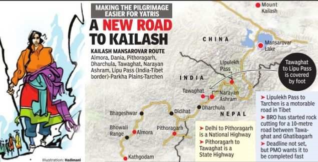
Another reason for India’s interest in Kalapani is religious. The Hindu nationalist Indian Prime Minister Narendra Modi wants to get the credit for opening a direct route to one of the holiest Hindu religious sites. The following map shows a new route to Kailash Mansarovar through Lipulekh Pass. Due to this new Kailash Mansarovar route, a five day trek will be reduced to two days of road travel thus saving six days of to and fro journey.
Map 10: Showing new Kailash Mansarovar Yatra route
Because of the interests mentioned above, India won’t be ready to easily settle the Kalapani dispute, and will look to drag it on indefinitely. But that should not hinder India and China from developing Lipulekh as a bilateral trade route. Nor should it stop Indian pilgrims from taking the new road to the abode of Shiva. Nepal, meanwhile, will continue to be reminded of the harsh realities of a small country wedged precariously between two giants.
Effrots made so far to solve Border Dispute :
1. In the 1980s, the two sides set up the Joint Technical Level Boundary Working Group to delineate the boundary.The group demarcated everything except Kalapani and Susta area.
2. Officially, Nepal brought the issue of Kalapani before India in 1998. Both sides agreed to demarcate the outstanding areas (including Kalapani) by 2002 at the prime ministerial level talk held in 2000. But that has not happened yet.
Way forward for Nepal:
1. Dialogue: The government of Nepal should start a dialogue with India as soon as possible to resolve the territorial dispute through political and diplomatic moves based on the provisions of the treaty signed between Nepal and India in 1998. The sooner, the better. It is obvious that India will not be ready easily to sit for the dialogue because it knows that it does not have proofs on the basis of which it can claim Kalapani, Lipulekh and Limpiyadhura as the parts of India. India will try its best to retain these territories within its control because of their defence, economic and religious importances.
2. Gathering of evidences: Though it is said that truth needs no proof, evidences are the only means to dismantle the artificial falsehood created by India regarding our territories. The collection of maps, census report of 2018 B.S., voters list of general election of 2015 B.S., the map of Nepal issued by India in 1857, etc. can strengthen our claim over our territories which are encroached by India.
3. Raising the issue of Kalapani territorial dispute in international forums : If India does not agree for dialogue and return our territory, then we will have to utilize every opportunity to ascertain our claim over Kalapani, Lipulekh and Limpiyadhura bringing this issue in international community and forums using our diplomatic channels to their fullest extent. By doing this, the international community will take notice of this issue and exert moral pressure on India to return our territories. The UN forum can also be a better platform to raise this issue in order to expose India’s expansionist policy.
4. Filling the case in International Court of Justice : In case, India does not become ready for the dialogue on the disputed territories, we will have to file the case in ICJ to regain our encroached territories by India presenting sufficient reliable historical , legal and other evidences . The ICJ will certainly come up with the solution of this dispute. Since we have plenty of strong evidences, it can be hoped that justice will come in our favour , and we will regain our encroached Kalapani, Lipulekh pass, and Limpiyadhura from India. It will be mandatory and there will be even moral pressure on India to accept the decision of the ICJ.
5. Tactful handling of the dispute: Since the Kalapani territorial dispute is directly concerned with territorial integrity and sovereignty of our country, it needs special and tactful handling from the government of Nepal. As it is mentioned in the constitution of our country, it is the duty of each and every Nepalese citizen and the government of Nepal to safeguard the territorial integrity and sovereignty of the country, all the people residing within the boundaries of the country should show strong solidarity with each and every step taken by the Nepal government.
6. Trust Building: It is the high time for the government of Nepal to take the opposition parties’ leaders and Mahesh based political parties’ leaders in confidence in the process of resolving the ongoing territorial dispute with India. There is a good sign coming from the opposition parties’ leaders as they have been standing firmly with the decisions taken by the government. There is no point in questioning the patriotism of Madheshi people and leaders in the safeguarding of territorial integrity and sovereignty of our country. It should not be forgotten that it is the Madheshi people who have been safeguarding the pillars on the border between Nepal and India. They have even fought against the India police force deployed for the safety on the border. There have been many reports in print and electronic media about their bravery and courage that they showed in fighting against Indian people and Police force who tried to encroach our Susta and Dashgaja regions. The Madheshi leaders and people must also show their solidarity with each and every step taken by the Government of Nepal for the safeguarding of the territorial integrity of our country coming to the forefront. About three crores of Nepalese citizens must come together and say univocally that Kalapani, Lipulekh and Limpiyadhura are our territories.
7. Package Deal: The government of Nepal should go for package deal with India including other border and territorial disputes as well such as Susta, Dashgaja regions, etc. The Susta region is located on the bank of Gandak river. The change of course by the Gandak river is the main reason for disputes in the Susta area between Nepal and India. Cases of Susta and Dashgaja regions’ encroachment by India are often reported in Nepali media , but no efforts seem to have been taken to resolve the Susta and Dashgaja region dispute.
8. Refraining from Media Trial: Since the Kalapani territorial dispute is our national concern, it must be handled carefully. Many arguments and counterarguments are being passed on in every print and electronic media as if they are the ones who will decide about the legal inheritance of the disputed territories. The media from both countries must understand the seriousness of the ongoing dispute between Nepal and India and they should refrain from the media trial of this serious territorial dispute at least for maintaining the cordial relations between the people of the two countries. Indian media seem to be more aggressive, illogical and even baseless because they keep on just crying in the absence of reliable evidences. As we know that, a thief has a louder voice, so is the case of Indian media. They are strengthening the claim of India over Kalapani, Lipulekh and Limpiyadhura which are not their territories. We must appreciate the Nepali media because they are highlighting the evidences and proofs instead of making unnecessary noise.
9. Being alert for possible blockade by India: Did we forget the blockade imposed on Nepal by India when Nepal passed its new Constitution ? Of course, not ! It was taken as a direct interference of India in internal affairs of Nepal. This time we are taking India on territorial dispute in order to regain our encroached territories from India. What’s the guarantee that India will not repeat this inhuman act again to torture us? Therefore, all necessary provisions are to be made before we sit with India for the dialogue to reclaim our territories.
10. Being skeptical about the intention of China as well: There arises an obvious question. Why did China not take Nepal in confidence when when it along with India built trade route through Lipulekh pass which is a tri-junction between Nepal, India and China? Does it not show the expansionist policy of both India and China? China’s silence with regard to this ongoing territorial dispute is skeptical. Though China says that the Kalapani dispute is an internal affair of Nepal and India, it will not certainly want to worsen its relation with India for the sake of Nepal because India is a very big market for China. Both India and China should have contacted Nepal and sought its permission before making trade route through Lipulekh pass if they were indeed the well wishers and good neighbours of Nepal. But, it did not happen so. It is enough to believe that they both do not miss even a chance to encroach the territory of Nepal. Recently, it was reported in the Chinese media that the Mt.Everest lies in China. This cannot be taken as a good and positive sign coming from India. The government of Nepal must understand the hidden motive and intensions of the China side as well. Being a small land locked country, we must be skeptical about each and every step of both the dragon and singh , because as soon as they get chance, they do not hesitate to encroach our territory.
Conclusion
By publishing a newly revised political map of Nepal, the government of Nepal has made its intention quite clear that it will adopt all the legal, political and diplomatic measures to reclaim the encroached territories of Nepal , namely Kalapani, Lipulekh pass and Limpiyadhura from India. The political leaders as well as diplomatic channels of both countries should sort out this territorial dispute as soon as possible. By returning these territories to Nepal, India will be able to maintain its goodwill not only in Nepal but also in its neighbouring countries at a time when India is not entertaining cordial relationships with its neighbours. It will also increase its goodwill in international arena that will ultimately help India in becoming one of the superpowers of the world. India must accept the bitter truth that it is rapidly losing its neighbours which is a very big setback in its dream of becoming the superpower of the world. And now, if India does not correct its present move of occupying Nepali lands, it is quite sure and certain that it will lose its good bilateral relations with Nepal as well. If India wishes to continue sound and cordial relationships with Nepal, it should end its occupation of Nepali lands and follow the provisions of Sugauly treaty and the 1950 Treaty of Peace and Friendship. Instead of maintaining status quo and delaying, the government of Nepal should bring this issue in the attention of international community and International Court of Justice. It should also have a collective dialogue with both India and China on this ongoing dispute to reach a reasonable conclusion in a peaceful way.
This is the right time and opportunity for the Nepal government to put a permanent end to border dispute with India as well as China. By tackling this ongoing territorial dispute with India politically and diplomatically in a smart way, the government of Nepal can not only regain the disputed regions Kalapani, Lipulekh pass and Limpiyadhura from India but also can get bigger appreciation from its own citizens. It is true that Nepal is a small land locked country, but it has the potentiality to become trade bridge between the two giants.